Once home to early riverside settlements, Kingsbridge was the site where the King’s Bridge was built and where the first uprisings took place. Later, it became a hub of life and industrialization. But the subway line built between the Bronx and Manhattan shifted the focus to other up-and-coming neighborhoods. What’s life like now in Kingsbridge, away from the bustling center of New York City? And what interesting historical facts about this place have survived to this day? We’ll tell you all about it in this article on bronx-future.
The History Behind the Name
Some New York City neighborhoods get their names from their location on a map (like East Village or Midtown), while others have simple abbreviations (like SoHo or DUMBO). However, some have kept their historical names, reflecting their past. For example, the Kingsbridge neighborhood in the Bronx is named after a real King’s Bridge.
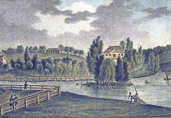
The Spuyten Duyvil Creek was a narrow waterway that once separated the northern tip of Manhattan from the Bronx. This small, seemingly innocent creek was known for its turbulent water, and many legends exist about people and animals drowning there. Its name translates to “Devil’s Spout.” But despite the danger, this creek was narrower and easier to cross than the wide Harlem River, so locals used it to get to the other shore.
In 1669, a Dutch farmer named Johannes Verveelen started a ferry service in the area, charging a fee. His clients were those who didn’t own their own boats. But as the population on both shores grew, there was a need for a more convenient and permanent solution for crossing.
A wealthy adventurer and royal family servant named Frederick Philipse appeared in these parts. He purchased a manor consisting of lands between Spuyten Duyvil Creek and the Croton River. These lands, once owned by the Lenape people and farmed by Dutch farmers, became part of Philipse’s holdings, which later turned into the western Bronx and Yonkers.
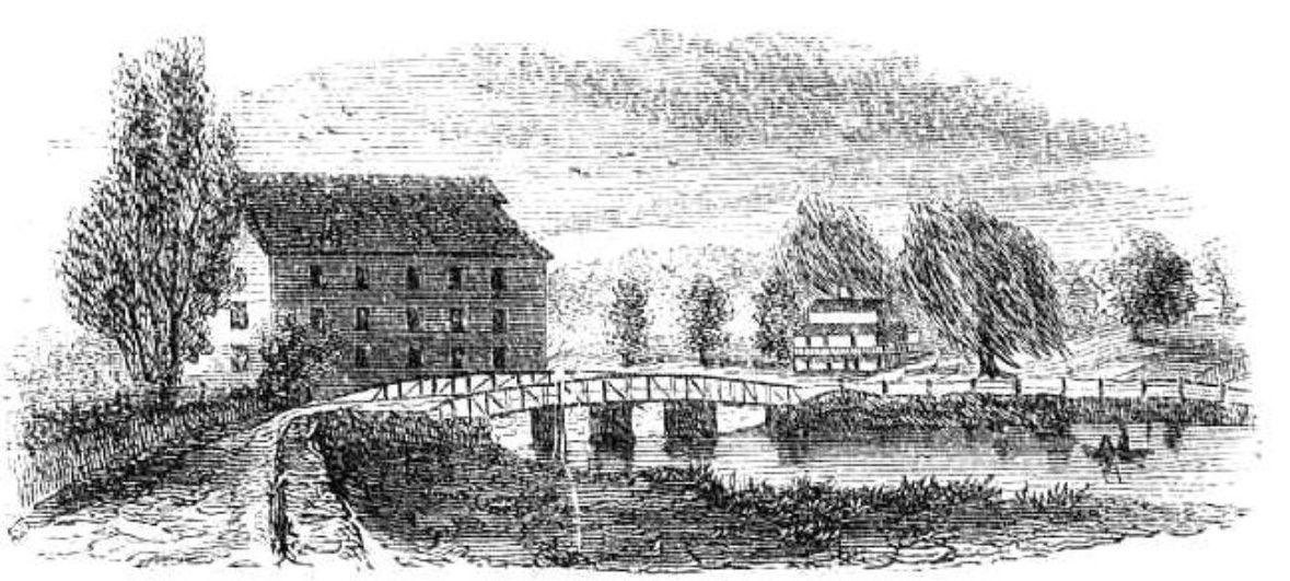
Frederick Philipse built a bridge, receiving a grant from the king to do so, and began charging a toll, a portion of which went to the royal treasury.
Naturally, people were outraged that they had to pay every time they crossed the bridge. In protest, farmers Benjamin Palmer and Jacob Dyckman built a wooden bridge in 1758 and called it “Free Bridge.” This was the occasion for a huge celebration with a feast and a roasted ox, which attracted thousands of people. However, Dyckman was not entirely an altruist—his family’s tavern, the Hyatt, was located near the bridge, so he was pursuing his own interests.
Dyckman’s bridge was later burned by British soldiers. The King’s Bridge was also destroyed by Washington’s troops during their retreat in 1776, but it was rebuilt after the war.
In 1914, Spuyten Duyvil Creek was closed and filled in to improve navigation on the Harlem River. There is no information about the fate of the King’s Bridge. Technically, it may still exist under the roadway at 230th Street and Broadway. But it certainly remains a part of history, as it gave its name to one of the Bronx’s neighborhoods—Kingsbridge.
Infrastructure and Landmarks
Kingsbridge is located in the valley between the Riverdale ridges to the west and Kingsbridge Heights to the east. In some places, the slopes are so steep that the streets turn into stairs (in some parts, the number of steps reaches 100).
This neighborhood, inhabited since the 1660s, is one of the oldest in the Bronx, according to historian Lloyd Ultan. It used to be mostly farmland with small villages, but after the IRT elevated subway line opened in 1908, the population began to grow rapidly.
The housing stock mainly consists of one- and two-story brick houses, many with yards. There are also five- and six-story apartment buildings from the 1920s and a few high-rises from the 1950s and ’60s.
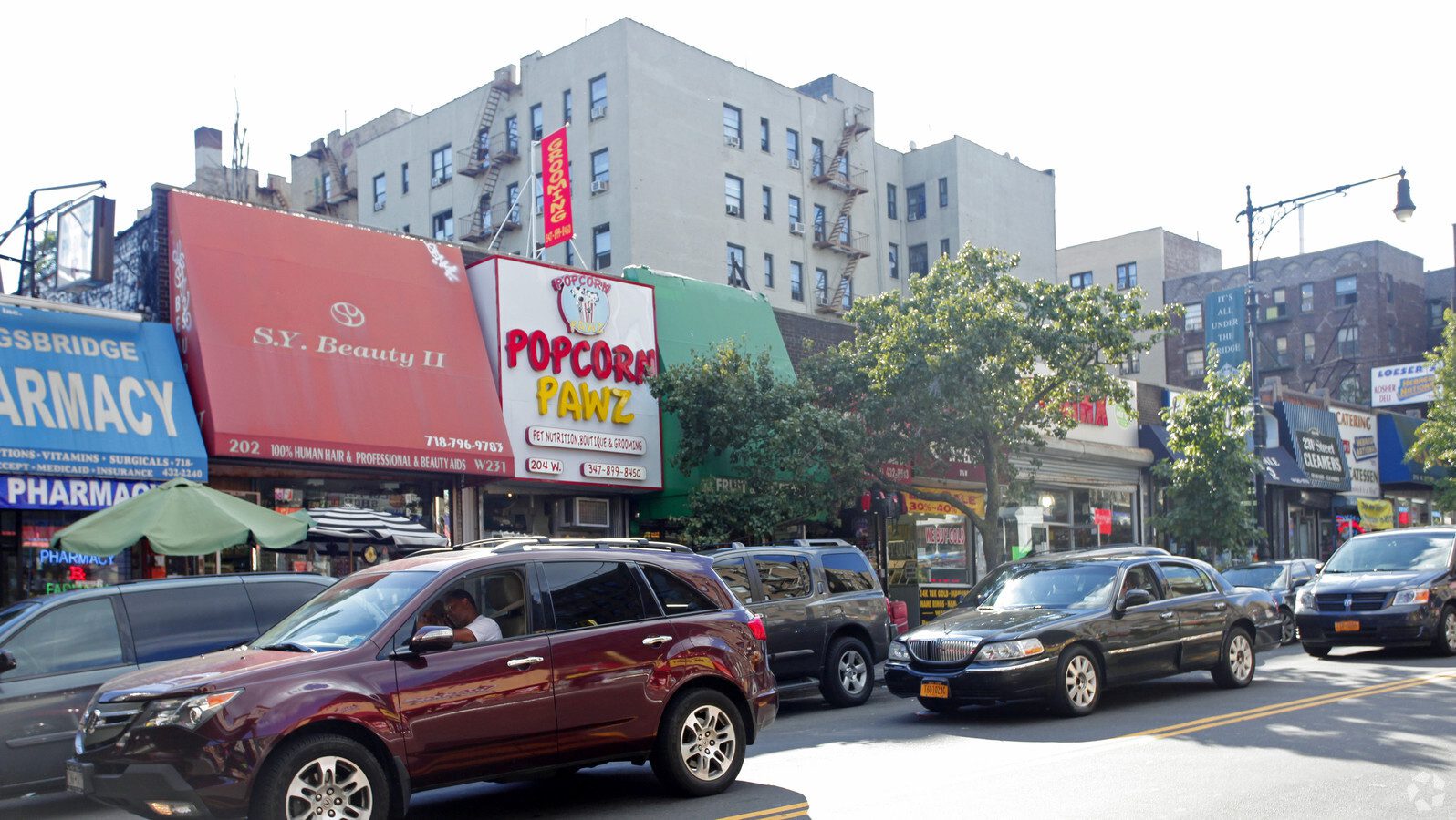
The commercial zone is located at the intersection of Broadway and West 231st Street. Here you can find many shops and representatives of large chains like Duane Reade, Staples, Blockbuster Video, and the Edwards supermarket. In recent years, there have been significant improvements to the community’s infrastructure, including the baseball field at 233rd and Bailey Avenue, which is managed by the Kingsbridge Little League. The field is equipped with lights, dugouts, stands, and a small food court.
The area has plenty of cafes and bars but lacks cozy coffee shops and restaurants for special occasions.
As for safety, the area is not very crime-ridden. Street crime is concentrated near the subway stations. The main problem is groups of teenagers who gather at Kingsbridge Avenue and West 231st Street. They are often loud, get into fights, and drink alcohol at night. Many people are concerned about the slow ambulance response, but the government has announced the construction of a new ambulance station near the intersection of West 230th Street and Tibbett Avenue, so this problem will soon be resolved.
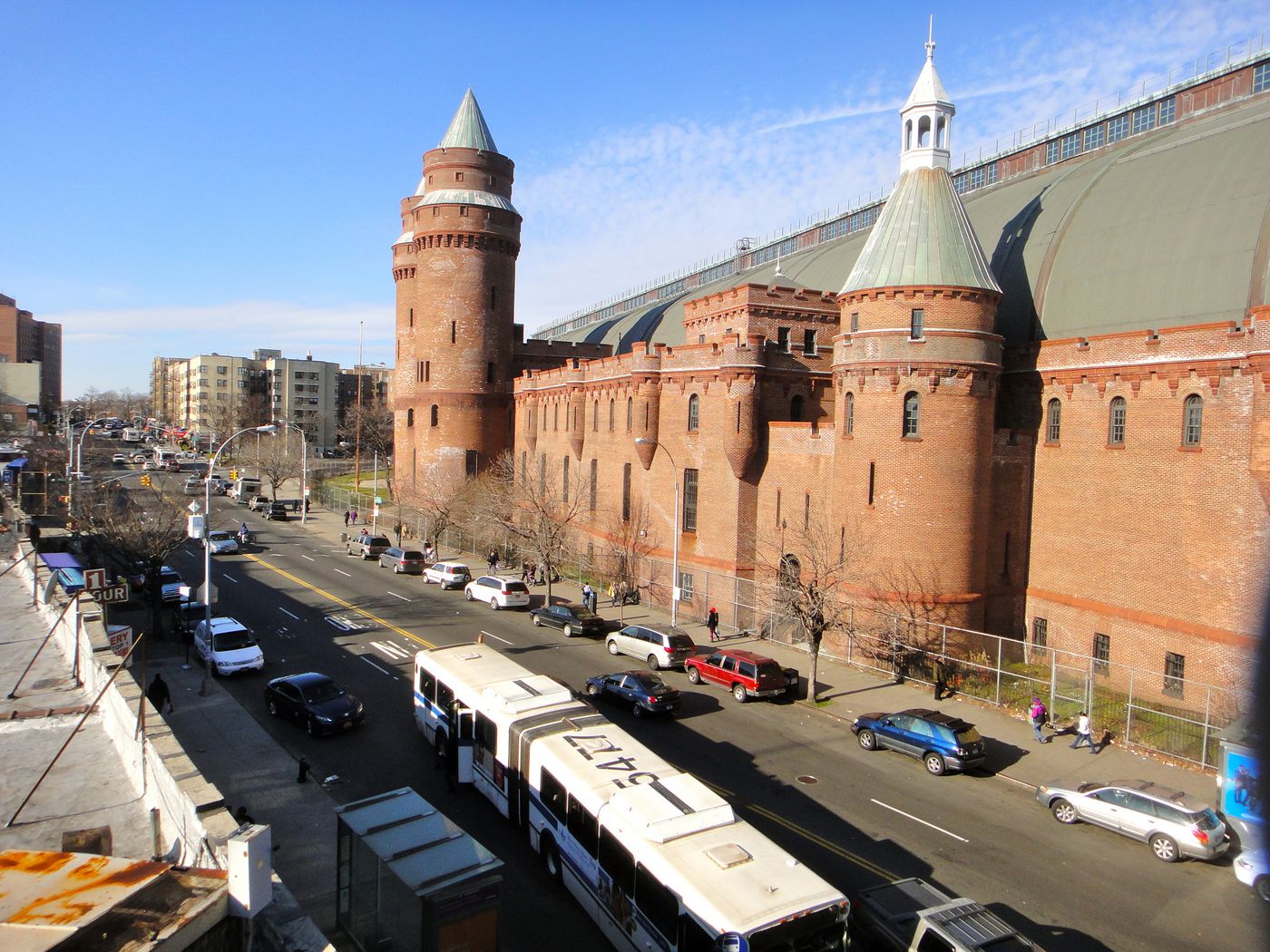
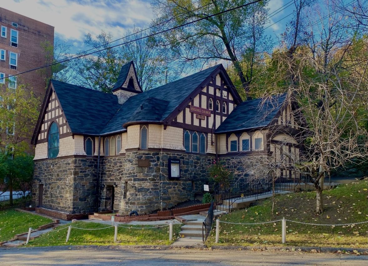
Kingsbridge has three middle schools, with plans for another one to be built. A local landmark is the Episcopal Church of the Mediator, founded in the mid-19th century. But now, this Gothic Revival stone building is under threat of demolition.
Read more about this church and its history here.
The Church of the Mediator also takes care of the Corlear Sycamore—one of the oldest and largest trees in the Bronx, which is so big that the sidewalk around it is cracked.
Once a Bustling Hub, Now a Quiet Town
Kingsbridge, which was always an important crossroads, has undergone changes. An old newspaper, now on display at the Church of the Mediator and likely written a century ago, contains an article titled “Around Old Kingsbridge: Adorned by Nature, Famous for Stories, One Hour’s Drive from City Hall.” This article read like an advertisement for the neighborhood, describing its many charms.
Its proximity to City Hall, the benefits of the new shipping channel through the Harlem River that was then under construction, picturesque landscapes, and a rich historical heritage were the reasons for its prosperity. In that article, Kingsbridge is compared to a web. It was like Rome, where all roads lead.
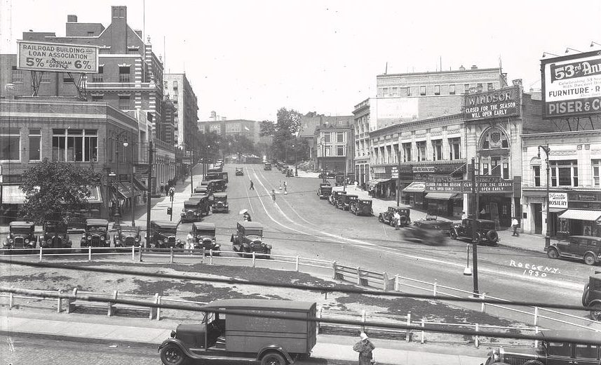
But when the 1 subway line was completed, Manhattan residents began to expand northward into the Bronx, a part of the city on the mainland. A trend was observed: wherever the subway went, progress, development, and most importantly, people followed. After the main transportation artery was laid through Kingsbridge, it began to lose its footing. The Kingsbridge of today is different from the one it used to be. Many locations, unfortunately, are no longer in operation. Among them: the former skating rink and bowling alley. The RKO and Dale movie theaters, as well as the Woolworth’s and Horn and Hardart retail stores, are gone. The ice cream parlor beloved by all locals, the knitting mill, and Walbaum’s are also gone.
The “United Nations”
Over the last few years, Kingsbridge has undergone significant demographic changes, but the neighborhood remains a haven for immigrants. Some of them arrive from other countries and make Kingsbridge their first stop on the way to achieving the American dream.
Reverend Diego Delgado-Miller from the Church of the Mediator noted that 15 years ago, most of his parishioners were white, but now you can count them on one hand. Today, they are mostly Hispanic people from different countries. According to the church’s estimates, the neighborhood is about 15% white, 16% African American, 60% Hispanic, 4% Asian, and 4% other.
Charlie Shayne, the executive director of the Kingsbridge Heights Community Center, where he has worked for 25 years, compared the neighborhood to the United Nations, as more than 53 countries are represented here.

The neighborhood is getting younger, as many new residents are young families starting their lives. Despite the growing diversity, there are almost no racial or ethnic conflicts in Kingsbridge. Everyone here lives in peace and harmony.
You can read about one of the new modern neighborhoods in the Bronx in this article.